


Update:
Polk County EMA Director Randy Lacey warns the public to be careful over the next day as severe weather comes into the area as Hurricane Zeta made landfall in Louisiana earlier this afternoon, and now is expected to move inland.
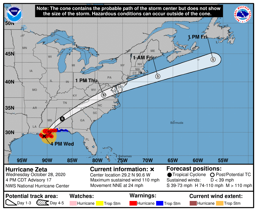
Rain showers are just starting to reach the area from the outer bands of the storm, which is set to be over Alabama overnight and by midday Thursday heading over the middle of Virginia and onward out to sea by Friday.
The fast-moving storm has Polk County under a Tropical Storm Warning, a Flash Flood Watch and a statement from the National Weather Service in Atlanta about Hurricane-like conditions moving through the area as the remnants of the storm move across North Georgia overnight and into Thursday.
Thunderstorms are likely after 11 p.m., and power outages are possible with wind and heavy rainfall. An inch to 2 inches of rain is expected, and Thursday’s forecast through 10 a.m. is much the same. Wind gusts over 20 mph are likely.
Lacey specifically cautions people to be aware of the weather forecast through the late evening hours and into Thursday, taking specific cautions amid the likelihood of severe weather.
Here’s a posting from the EMA earlier on Facebook:
Those include avoiding driving through flooded roadways and maneuvering around downed trees and power lines. See below for other information about severe weather advice.
Reminder for parents: the Polk School District is utilizing a Distance Learning Day tomorrow due to the weather forecast. Haralson, Paulding, Bartow and Floyd County Schools are also closed tomorrow, per WGAA Radio. So is Covenant Christian School.
GNTC is also closing campuses tomorrow as well.
Hurricane Zeta made landfall in Louisiana earlier in the afternoon and hundreds of thousands of power customers were in the dark tonight as the storm moves over Southeast Louisiana and on a northeast track toward the east coast. Damage reports are already coming in for the Category 2 hurricane, the 27th named storm and the fifth to hit the region in recent months.
Check back for more updates as the storm moves into the area overnight.
Previously posted:
That headline is accurate, Polk County. As October is set to come to an end in the days ahead, Polk County is likely to face another round of tropical weather moving inland overhead, and with it bring the potential for lots of rain, flash flooding and windy conditions.
A Tropical Storm Warning went into effect at 11:04 a.m., with the threat of winds at least 30 to 40 mph, and gusting up to 55 mph as the hurricane loses strength as it moves inland tomorrow, with the majority of the windy conditions expected early Thursday morning.
The warning also calls for flooding rain, with at least an inch of rain expected and upward of 3 inches before the storm passes through northeast. There is also some favorability for the potential for tornadic activity as well.
The Flash Flood watch that began this morning will continue through Thursday at 8 p.m. The Tropical Storm Warning is calling for potential impacts over the next 36 hours.
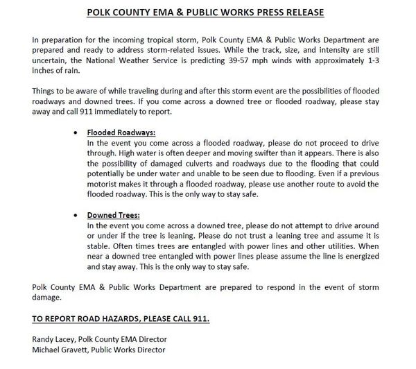
Please be on the lookout for fallen trees, downed power lines and other potential hazards if out traveling tonight and tomorrow in Polk County. Additionally, for those in low-lying areas, please have a plan in place if waters begin to rise and flooding occurs. Do not attempt to drive over streets that are flooded, as your vehicle may stall.
With the threat of high winds and lots of rain, also have supplies on hand in case the power goes out, and keep them in an area easy to find in the dark. Your supplies should include candles, an ignition source like matches or a lighter, batteries, flashlights, a weather radio, at least a three-day supply of food and water, a first aid kit, changes of clothing, and blankets that are kept in a dry, safe space.
Keep track of the progress of Hurricane Zeta here.
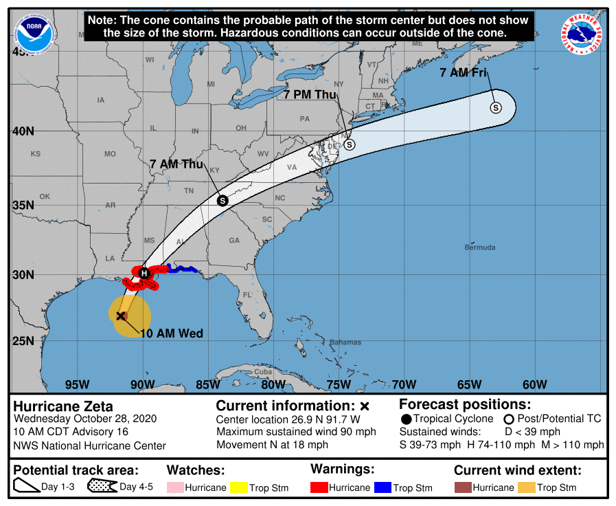
Hurricane Zeta is moving fast toward Louisiana and is expected to make landfall as a hurricane, then pass over southern Mississippi and central Alabama before heading toward Northwest Georgia, the regions of East Tennessee and Western North Carolina before making a pass over Virginia and Washington, D.C. and heading back out by Friday morning as a low-grade Tropical Storm or Depression.
The Gulf Coast is expected to get “life threatening storm surge” according to the National Weather Service from the Category 2 storm.
It was closing in this morning on the New Orleans metro area, expected to make landfall sometime today.
Zeta is the 27th named storm of the season, and is this season’s 11th hurricane so far.


Leave a Reply